![](/images/other/stat-length.png)
![Tocht Mountainbike Les Monts d'Aunay - Raid des martiens 2010 - Aunay sur Odon - Photo](https://media.geolcdn.com/t/1900/400/ext.pjpeg?maxdim=2&url=https%3A%2F%2Fstatic1.geolcdn.com%2Fsiteimages%2Fupload%2Ffiles%2F1524743154velo.jpg)
Raid des martiens 2010 - Aunay sur Odon
tracegps
Gebruiker
![Lengte](/images/other/stat-length.png)
Lengte
55 km
![Max. hoogte](https://static1.geolcdn.com/siteimages/upload/files/1508320355ic_sort_altitude_max_24dp.png)
Max. hoogte
359 m
![Positief hoogteverschil](https://static1.geolcdn.com/siteimages/upload/files/1508320355ic_sort_den_pos_24dp.png)
Positief hoogteverschil
1201 m
![Km-Effort](/images/other/stat-length.png)
Km-Effort
71 km
![Min. hoogte](https://static1.geolcdn.com/siteimages/upload/files/1508320355ic_sort_altitude_min_24dp.png)
Min. hoogte
124 m
![Negatief hoogteverschil](https://static1.geolcdn.com/siteimages/upload/files/1508320355ic_sort_den_neg_24dp.png)
Negatief hoogteverschil
1201 m
![Boucle](https://static1.geolcdn.com/siteimages/upload/files/16400158638029165_repeat_loop_refresh_sync_direction_icon.png)
Boucle
Ja
Datum van aanmaak :
2014-12-10 00:00:00.0
Laatste wijziging :
2014-12-10 00:00:00.0
![Mountainbike](https://static1.geolcdn.com/sitytour/trail-icons/202.png)
4h00
Moeilijkheid : Moeilijk
![Scan deze QR-code om de tocht te openen in de SityTrail-applicatie](https://capi.geolives.com/qq0zvz2zws4bq2lad0pu/sitytour/trails/105256/qr.png?size=200)
Gratisgps-wandelapplicatie
Over ons
Tocht Mountainbike van 55 km beschikbaar op Normandië, Calvados, Les Monts d'Aunay. Deze tocht wordt voorgesteld door tracegps.
Beschrijving
Très jolie randonnée composée de sentiers de différentes natures aux reliefs divers et variés et offrant de somptueux paysages, de quoi allier effort physique et plaisir des yeux ;)
Plaatsbepaling
Land:
France
Regio :
Normandië
Departement/Provincie :
Calvados
Gemeente :
Les Monts d'Aunay
Locatie:
Unknown
Vertrek:(Dec)
Vertrek:(UTM)
673242 ; 5432045 (30U) N.
Opmerkingen
Wandeltochten in de omgeving
![Tocht Mountainbike Les Monts d'Aunay - Boucle d'Aunay via Hamars - Photo](https://media.geolcdn.com/t/375/260/ext.jpg?maxdim=2&url=https%3A%2F%2Fservices.sitytrail.com%2FGeolivesWS%2FDownloadMedia.ashx%3FTrailID%3D191363%26Media%3D14929_6.jpg)
![Mountainbike Mountainbike](https://static1.geolcdn.com/sitytour/trail-icons/202.png)
Boucle d'Aunay via Hamars
Mountainbike
Moeilijk
Les Monts d'Aunay,
Normandië,
Calvados,
France
![](/images/other/stat-length.png)
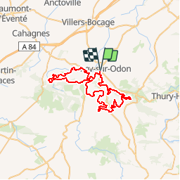
26 km | 33 km-effort
2h 0min
![](https://static1.geolcdn.com/siteimages/upload/files/16400158638029165_repeat_loop_refresh_sync_direction_icon.png)
Ja
![Tocht Mountainbike Les Monts d'Aunay - L'Arbre de la Liberté - Chartres - Photo](https://media.geolcdn.com/t/375/260/ext.jpg?maxdim=2&url=https%3A%2F%2Fservices.sitytrail.com%2FGeolivesWS%2FDownloadMedia.ashx%3FTrailID%3D172787%26Media%3D14216_5.jpg)
![Mountainbike Mountainbike](https://static1.geolcdn.com/sitytour/trail-icons/202.png)
L'Arbre de la Liberté - Chartres
Mountainbike
Medium
Les Monts d'Aunay,
Normandië,
Calvados,
France
![](/images/other/stat-length.png)
2756 km | 3635 km-effort
3h 19min
![](https://static1.geolcdn.com/siteimages/upload/files/16400158638029165_repeat_loop_refresh_sync_direction_icon.png)
Neen
![Tocht Mountainbike Les Monts d'Aunay - NormVass 2/6 7juin2022 - Photo](https://media.geolcdn.com/t/375/260/d0bc5af3-e059-40cb-bedf-b1f6bca4eeba.jpg&format=jpg&maxdim=2)
![Mountainbike Mountainbike](https://static1.geolcdn.com/sitytour/trail-icons/202.png)
NormVass 2/6 7juin2022
Mountainbike
Zeer moeilijk
Les Monts d'Aunay,
Normandië,
Calvados,
France
![](/images/other/stat-length.png)
47 km | 59 km-effort
8h 36min
![](https://static1.geolcdn.com/siteimages/upload/files/16400158638029165_repeat_loop_refresh_sync_direction_icon.png)
Neen
![Tocht Te voet Les Monts d'Aunay - Sous les monts d'Aunay - Photo](https://media.geolcdn.com/t/375/260/b08a1bcf-1ecf-49f8-87f9-ebee83161d95.jpeg&format=jpg&maxdim=2)
![Te voet Te voet](https://static1.geolcdn.com/sitytour/trail-icons/100.png)
Sous les monts d'Aunay
Te voet
Gemakkelijk
Les Monts d'Aunay,
Normandië,
Calvados,
France
![](/images/other/stat-length.png)
8 km | 9,4 km-effort
2h 7min
![](https://static1.geolcdn.com/siteimages/upload/files/16400158638029165_repeat_loop_refresh_sync_direction_icon.png)
Ja
![Tocht Te voet Malherbe-sur-Ajon - La Vallée de l'Ajon - Photo](https://media.geolcdn.com/t/375/260/526b3219-597e-49aa-b241-0b2c006314c6.jpeg&format=jpg&maxdim=2)
![Te voet Te voet](https://static1.geolcdn.com/sitytour/trail-icons/100.png)
La Vallée de l'Ajon
Te voet
Gemakkelijk
Malherbe-sur-Ajon,
Normandië,
Calvados,
France
![](/images/other/stat-length.png)
14,4 km | 17,3 km-effort
3h 55min
![](https://static1.geolcdn.com/siteimages/upload/files/16400158638029165_repeat_loop_refresh_sync_direction_icon.png)
Ja
![Tocht Stappen Les Monts d'Aunay - ROUCAMPS 2 - Photo](https://media.geolcdn.com/t/375/260/ext.jpg?maxdim=2&url=https%3A%2F%2Fstatic1.geolcdn.com%2Fsiteimages%2Fupload%2Ffiles%2F1553511878bg_sport_marche.png)
![Stappen Stappen](https://static1.geolcdn.com/sitytour/trail-icons/101.png)
ROUCAMPS 2
Stappen
Moeilijk
Les Monts d'Aunay,
Normandië,
Calvados,
France
![](/images/other/stat-length.png)
8,7 km | 11,2 km-effort
2h 52min
![](https://static1.geolcdn.com/siteimages/upload/files/16400158638029165_repeat_loop_refresh_sync_direction_icon.png)
Ja
![Tocht Te voet Le Mesnil-au-Grain - Petit Tour à Bauquay - Photo](https://media.geolcdn.com/t/375/260/ext.jpg?maxdim=2&url=https%3A%2F%2Fstatic1.geolcdn.com%2Fsiteimages%2Fupload%2Ffiles%2F1545311037marcheuse_200dpi.jpg)
![Te voet Te voet](https://static1.geolcdn.com/sitytour/trail-icons/100.png)
Petit Tour à Bauquay
Te voet
Gemakkelijk
Le Mesnil-au-Grain,
Normandië,
Calvados,
France
![](/images/other/stat-length.png)
4,3 km | 5,3 km-effort
1h 11min
![](https://static1.geolcdn.com/siteimages/upload/files/16400158638029165_repeat_loop_refresh_sync_direction_icon.png)
Ja
![Tocht Te voet Malherbe-sur-Ajon - Circuit de l'Orgueil - Photo](https://media.geolcdn.com/t/375/260/ext.jpg?maxdim=2&url=https%3A%2F%2Fstatic1.geolcdn.com%2Fsiteimages%2Fupload%2Ffiles%2F1545311037marcheuse_200dpi.jpg)
![Te voet Te voet](https://static1.geolcdn.com/sitytour/trail-icons/100.png)
Circuit de l'Orgueil
Te voet
Gemakkelijk
Malherbe-sur-Ajon,
Normandië,
Calvados,
France
![](/images/other/stat-length.png)
5,6 km | 6,6 km-effort
1h 30min
![](https://static1.geolcdn.com/siteimages/upload/files/16400158638029165_repeat_loop_refresh_sync_direction_icon.png)
Ja
![Tocht Te voet Les Monts d'Aunay - Sous le Mont d'Ancre - Photo](https://media.geolcdn.com/t/375/260/ext.jpg?maxdim=2&url=https%3A%2F%2Fstatic1.geolcdn.com%2Fsiteimages%2Fupload%2Ffiles%2F1545311037marcheuse_200dpi.jpg)
![Te voet Te voet](https://static1.geolcdn.com/sitytour/trail-icons/100.png)
Sous le Mont d'Ancre
Te voet
Gemakkelijk
Les Monts d'Aunay,
Normandië,
Calvados,
France
![](/images/other/stat-length.png)
13,2 km | 17,3 km-effort
3h 55min
![](https://static1.geolcdn.com/siteimages/upload/files/16400158638029165_repeat_loop_refresh_sync_direction_icon.png)
Ja